Utilizing Remote Sensing for Accurate Forest Segmentation

Discover how remote sensing techniques can be utilized for accurate forest segmentation and analysis.
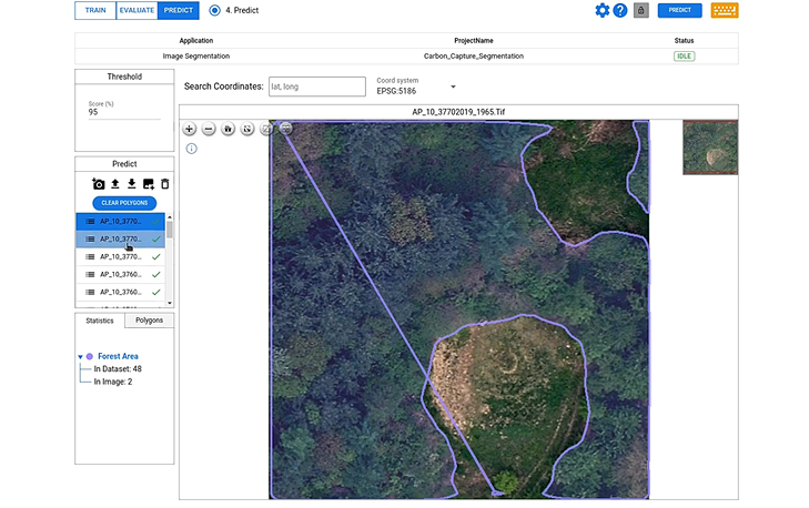
Meet our latest forest segmentation model! Check out the video for more details.
If you want to try this model, check it out at the this link.
The Importance of Forest Segmentation
Forest segmentation plays a crucial role in understanding and managing forest ecosystems. By dividing the forest into distinct segments, it becomes easier to analyze and monitor various aspects such as species distribution, forest health, and biodiversity. This segmentation allows researchers and environmentalists to gain valuable insights into the structure and composition of forests, enabling them to make informed decisions for conservation and sustainable management.
Furthermore, accurate forest segmentation is essential for applications like forest inventory, mapping, and ecological modeling. By accurately delineating different forest classes, such as coniferous and deciduous trees, it becomes possible to estimate the volume, biomass, and carbon storage of forests. This information is invaluable for assessing the overall health and productivity of forest ecosystems, as well as for planning and implementing effective forest management strategies.
Remote Sensing Techniques for Forest Segmentation
Remote sensing techniques play a vital role in forest segmentation by providing detailed and comprehensive information about forests from a distance. These techniques involve the use of various sensors, such as satellites and airborne platforms, to capture images of the Earth's surface. These images contain valuable information about the spectral properties of different land cover types, including forests.
One commonly used remote sensing technique for forest segmentation is the analysis of optical imagery. By analyzing the reflectance values of different wavelengths, it becomes possible to differentiate between various forest classes. For example, healthy and stressed vegetation may exhibit different spectral signatures, allowing for the identification of areas at risk or in need of intervention.
Other remote sensing techniques for forest segmentation include LiDAR (Light Detection and Ranging) and radar imagery. LiDAR data provides detailed information about the vertical structure of forests, allowing for the estimation of tree heights and canopy density. Radar imagery, on the other hand, is particularly useful for forest segmentation in areas with dense cloud cover or during night-time. By utilizing different remote sensing techniques in combination, it becomes possible to obtain a more comprehensive and accurate understanding of forest ecosystems.
Automated Segmentation of Forest in Remote Sensing Images
Manual segmentation of forests in remote sensing images can be a time-consuming and labor-intensive task. To overcome this challenge, automated segmentation algorithms have been developed to efficiently and accurately delineate forest areas. These algorithms utilize advanced image processing and machine learning techniques to analyze the spectral and spatial characteristics of remote sensing images.
One notable automated segmentation method is the use of deep learning models, such as DeepBlock.net. These models are trained on large datasets of labeled remote sensing images, allowing them to learn the complex relationships between spectral features and forest classes. By leveraging the power of deep neural networks (DNNs), these models can achieve high accuracy in forest segmentation tasks.
The automated segmentation of forests in remote sensing images not only saves time and resources but also enables the analysis of large-scale forest areas. It allows for the monitoring of changes in forest cover over time, the identification of forest disturbances or encroachments, and the assessment of the effectiveness of conservation efforts.
DeepBlock.net and Automated Forest Segmentation
DeepBlock.net is a state-of-the-art deep learning platform specifically designed for remote sensing image analysis. Deep Block can handle large size remote sensing images that are really high in resolutuio to handle multispectral and hyperspectral data. It has been trained on extensive datasets to accurately classify different forest classes and provide detailed segmentation maps.
By utilizing DeepBlock.net, researchers and environmentalists can automate the process of forest segmentation, saving valuable time and resources. The model can analyze large volumes of remote sensing images and provide accurate and consistent results. This enables more efficient monitoring and analysis of forest ecosystems, contributing to better decision-making for forest management and conservation.
Advantages of Automated Forest Segmentation
Automated forest segmentation offers several advantages over manual segmentation methods. Firstly, it significantly reduces the time and effort required for segmentation tasks. By automating the process, large-scale forest areas can be analyzed quickly and efficiently, allowing for better monitoring and management of forests.
Secondly, automated forest segmentation provides more consistent and reproducible results. Manual segmentation can be subjective and prone to human errors, leading to inconsistencies and inaccuracies. Automated algorithms, on the other hand, follow predefined rules and criteria, ensuring consistent and reliable segmentation outputs.
Furthermore, automated forest segmentation can handle large volumes of remote sensing data, allowing for comprehensive analysis and monitoring of forest ecosystems. This scalability is particularly beneficial for applications such as forest inventory, where accurate and up-to-date information is essential for decision-making.
Overall, automated forest segmentation improves the efficiency, consistency, and scalability of forest analysis, enabling better understanding and management of forest ecosystems.
Challenges and Limitations of Remote Sensing in Forest Segmentation
While remote sensing techniques offer numerous benefits for forest segmentation, they also come with certain challenges and limitations. One challenge is the presence of cloud cover, which can obstruct the acquisition of clear and high-quality remote sensing images. Clouds can limit the availability of data and affect the accuracy of forest segmentation algorithms. To address this challenge, researchers and practitioners are exploring the use of radar and LiDAR imagery, which are less affected by cloud cover.
Another limitation is the complexity of forest ecosystems. Forests are diverse and dynamic, with various species, vegetation types, and structural characteristics. This complexity can pose challenges for accurate forest segmentation, as differentiating between similar forest classes can be difficult. Ongoing research aims to improve the accuracy and robustness of forest segmentation algorithms by incorporating more advanced machine learning techniques and utilizing a combination of remote sensing data sources.
Additionally, the availability and cost of remote sensing data can be a limiting factor for forest segmentation. High-resolution and multispectral data can be expensive to acquire, especially for large-scale applications. To overcome this limitation, researchers can adopt few shot learning algorithms to automate forest segmentation.
Despite these challenges, remote sensing continues to be a valuable tool for forest segmentation and analysis. Ongoing advancements in technology and research hold great promise for improving the accuracy and efficiency of forest segmentation algorithms, enabling better management and conservation of forest ecosystems.


