The Power of Remote Sensing Technology: Automatically Detects Changes of the Earth.

Discover the incredible potential of remote sensing technology and how it is revolutionizing various industries.
Understanding Remote Sensing Technology
Remote sensing technology refers to the use of sensors to collect data about the Earth's surface and atmosphere from a distance. It involves the detection and measurement of electromagnetic radiation, which is then used to analyze and interpret various features and changes in the environment. This technology has proven to be invaluable in a wide range of industries, including agriculture, environmental monitoring, urban planning, and disaster management.
By utilizing different sensors, such as satellites, airplanes, or drones, remote sensing technology can capture images and data in different wavelengths, allowing scientists and researchers to obtain valuable insights about the Earth's surface. These insights can be used to monitor land cover changes, track vegetation health, detect pollution, and even predict natural disasters.
The advancements in remote sensing technology have opened up new possibilities for industries and researchers alike. With the availability of high-resolution images and advanced data processing techniques, the accuracy and precision of remote sensing have greatly improved. This has led to more accurate mapping, better resource management, and enhanced decision-making processes.
Applications of Land Change Detection
Land change detection is one of the key applications of remote sensing technology. It involves analyzing satellite images or aerial photographs to identify and monitor changes in land cover and land use over time. This information is crucial for understanding the impact of human activities on the environment, assessing the effectiveness of land management policies, and planning for sustainable land use.
Some common applications of land change detection include monitoring deforestation and forest degradation, mapping urban expansion, assessing changes in agricultural land use, and tracking the spread of invasive species. By analyzing historical satellite imagery and comparing it with current data, researchers can quantify and visualize the changes that have occurred, providing valuable insights for environmental conservation and land management strategies.
Moreover, land change detection can also contribute to climate change studies by monitoring changes in carbon stocks, analyzing the impact of land use change on greenhouse gas emissions, and assessing the effectiveness of carbon sequestration initiatives.
Challenges in Analyzing Remote Sensing Images
Despite its numerous benefits, analyzing remote sensing images comes with its fair share of challenges. The sheer volume of data generated by remote sensing platforms can be overwhelming, making it difficult to process and extract meaningful information. Additionally, variations in image quality, atmospheric conditions, and sensor characteristics can introduce noise and errors in the data, affecting the accuracy of analysis.
Another challenge lies in the size of remote sensing data. The resolution of remote sensing images is very high, and the file size of these images is also very large. The amount of images that need to be analyzed is also quite a lot, and implementing software technologies to handle these images is very challenging.
Furthermore, the integration of remote sensing data with other geospatial datasets, such as geospatial metadata or topographic information, can present technical and logistical challenges. Ensuring data compatibility, handling different coordinate systems, and managing large datasets require specialized skills.
Addressing these challenges is crucial to fully unleash the potential of remote sensing technology and maximize its benefits across various industries.
Automated Land Change Detection Using Image Comparison Technology
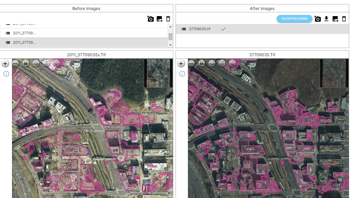
In recent years, advancements in image processing and machine learning algorithms have enabled the development of automated land change detection systems. These systems leverage image comparison technology to detect and quantify changes in land cover over time.
By comparing multi-temporal satellite images, these systems can identify areas where land cover has changed, whether due to natural causes or human activities. The use of advanced algorithms, such as change vector analysis or object-based image analysis, allows for the detection of subtle changes that may not be apparent to the naked eye.
Automated land change detection systems offer several advantages. They can significantly reduce the time and effort required for manual analysis, allowing for more efficient and frequent monitoring of land cover changes. Moreover, the use of objective and standardized algorithms helps to minimize subjectivity and increase the accuracy and reliability of the results.
These systems find applications in various fields, including environmental monitoring, urban planning, and land management. They provide valuable insights for decision-makers, enabling them to make informed choices about resource allocation, conservation measures, and land use planning.
DeepBlock.net's Advanced Machine Learning Change Detection Software for High Resolution Remote Sensing Images
DeepBlock.net is at the forefront of developing advanced machine learning change detection software for high-resolution remote sensing images. Deep Block utilizes deep learning algorithms to achieve state-of-the-art performance in detecting and analyzing land cover changes.
DeepBlock.net's pre-trained change detection model can accurately identify land cover changes. This includes detecting changes in vegetation, urban infrastructure, water bodies, and other land features. The software can also quantify the extent and magnitude of the changes, providing valuable information for land management and environmental monitoring.
The use of deep learning techniques allows for the extraction of complex patterns and features from high-resolution images, leading to more accurate and detailed change detection results. DeepBlock.net's software is designed to handle large datasets and can process images from various remote sensing platforms, including satellites and drones.
With the continuous advancements in machine learning and remote sensing technology, DeepBlock.net is at the forefront of driving innovation in change detection and analysis. DeepBlock.net is set to revolutionize the way we monitor and manage land cover changes, opening up new possibilities for sustainable development and environmental conservation.


